Have you ever found yourself lost in the woods, disoriented, and unsure how to return to safety? Whether you’re an experienced outdoorsman or a casual hiker, getting lost can be a frightening experience. But fear not, for even in the most remote locations, there are different navigation techniques to find your way back.
Different navigation techniques include celestial navigation, which relies on stars and celestial bodies as guides; land navigation, which involves map reading and compass use; and GPS navigation, which integrates technology for accurate positioning.
This article delves into navigation techniques, exploring traditional and modern methods that can guide you through the wilderness. Learning how to improve land navigation skills can empower you to navigate and ensure a safe and enjoyable outdoor experience confidently.
Understanding Your Environment

Throughout my 15-plus years spent navigating the wilderness, I’ve encountered countless situations where understanding and utilizing various navigation techniques became crucial. From honing my skills during my military service to teaching countless individuals the art of self-sufficiency, I’ve come to appreciate the immense value of mastering these essential tools.
Before diving into specific techniques, developing a keen awareness of your surroundings is crucial. This involves honing your observational skills to leverage natural signs, landmarks, and terrain features for direction, finding, and establishing your position.
A 2014 study published in the journal “Songlines and Navigation in Wardaman and Other Australian Aboriginal Cultures” examined the navigation survival skills of Aboriginal Australians.
The study found that Aboriginal participants, relying solely on natural signs and landmarks, were able to navigate unfamiliar terrain with remarkable accuracy. This research highlights the effectiveness of traditional navigation techniques honed over generations. It also emphasizes the potential for anyone to develop and embrace these survival techniques and skills.
Reading Nature’s Signs
The natural world offers a wealth of information for those who know how to interpret it. Here are some key celestial and terrestrial clues you can utilize:
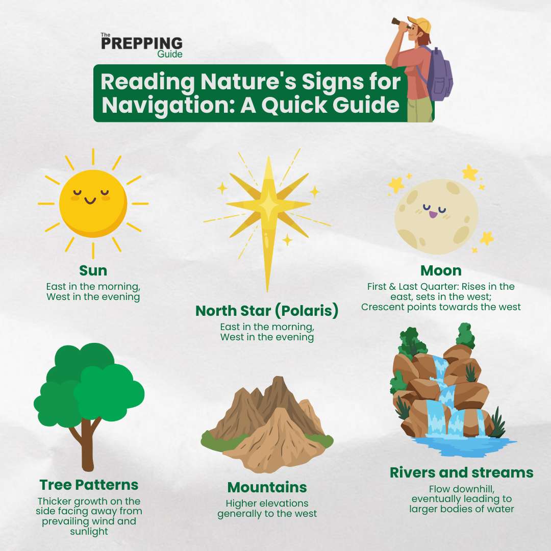
The Sun: Our closest star’s predictable path across the sky can be a valuable tool. At sunrise, the sun rises in the east and sets in the west. By midday, it sits roughly south in the Northern Hemisphere and north in the Southern Hemisphere. Observing its position gives you a rough idea of your cardinal directions.
Stars: While navigating by the stars requires some practice, it can be incredibly accurate. The North Star, Polaris, stays nearly fixed in the night sky and always points north. By locating the Big Dipper constellation and drawing an imaginary line through the two stars at the “tip” of the cup, you can find Polaris. Once you’ve identified Polaris, you can use it as a reference point to determine north.
The Moon: Similar to the sun, the moon’s phases can provide directional cues. During the first and last quarters, the moon rises roughly in the east and sets in the west, and at full and new moons, it rises and sets closer to sunrise and sunset, respectively. While not as precise as the sun or stars, the moon can offer a general sense of direction, especially when combined with other natural signs.
Tree Patterns: Trees growing on slopes tend to have thicker growth on the side, facing away from the prevailing wind and sunlight. By observing the moss or lichen growth on trees, you can often determine the direction of the north, as these elements tend to thrive on the cooler and shadier side, typically the north side in many regions.
Landmarks and Terrain Features
The landscape itself can offer valuable clues for navigation. Here are some key features to pay attention to:
Mountains: Mountains can serve as prominent landmarks, aiding in establishing your position and guiding your direction.
Rivers and Streams: Rivers and streams generally flow downhill, eventually leading to larger bodies of water like lakes or oceans. By understanding the flow of water, you can often determine the general direction of lower-lying terrain and potentially find your way back to civilization.
Man-made Landmarks: While relying solely on man-made structures is not recommended, they can sometimes provide valuable clues in conjunction with natural features. Power lines, roads, and even distant buildings can be used as reference points to help orient yourself.
Remember, relying solely on any single method is not ideal. By combining your understanding of natural signs, landmarks, and terrain features, you can develop a comprehensive sense of your surroundings and navigate with greater confidence in the wild.
Traditional Navigation Techniques
Even in the age of advanced GPS technology, traditional navigation techniques remain valuable tools for outdoor enthusiasts. These methods, honed over centuries, can be surprisingly accurate and offer a sense of self-reliance in the wilderness.
Here are some key traditional navigation techniques to add to your skillset:
1. Shadow Stick Method
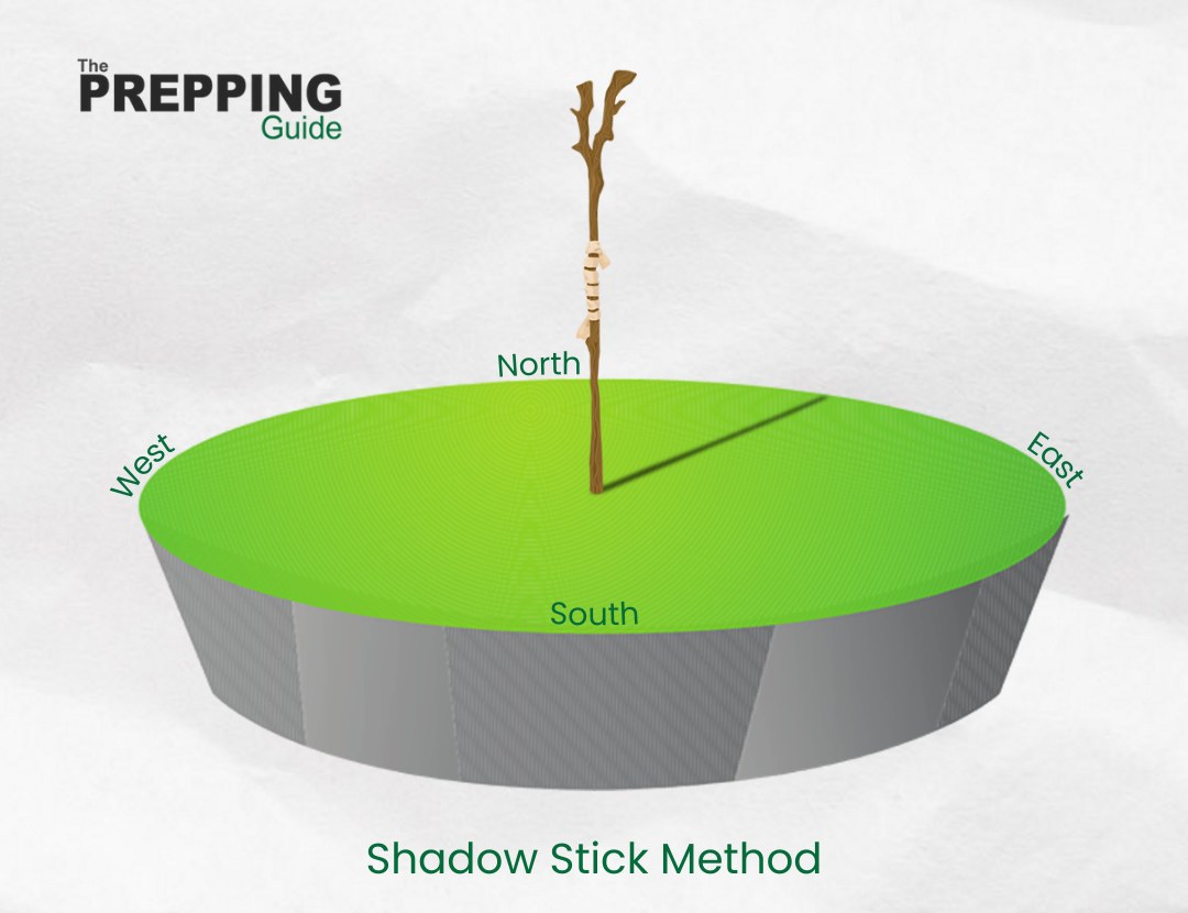
This simple method utilizes the sun’s position to determine cardinal directions. Here’s how:
- Find a level area: Locate a flat, clear patch of ground where you can plant a stick upright.
- Mark the stick’s base: Push the stick firmly into the ground and mark its base with a stone or other object.
- Observe the shadow: Watch how the sun’s position changes throughout the day. The shadow cast by the stick will rotate throughout the morning and afternoon.
- Track the shadow’s movement: Every 15-20 minutes, mark the tip of the shadow with a small stone or other marker. By connecting these points, you create a rough sundial.
- Determine direction: North lies halfway between the morning and afternoon positions of the shadow’s tip.
2. Watch Method
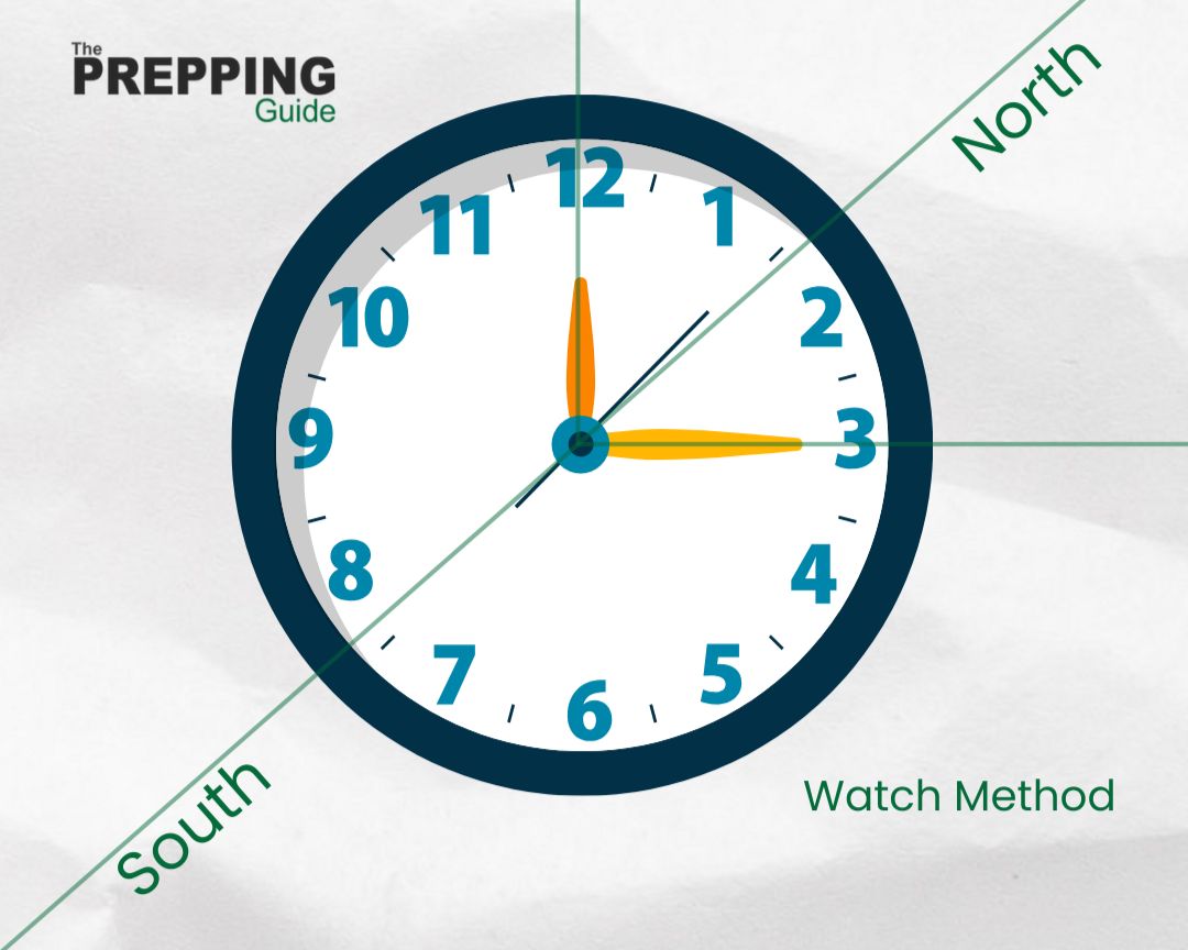
With a little ingenuity, you can turn your analog watch into a makeshift compass. Here’s what you need:
- Point the hour hand towards the sun: Hold your watch level, with the 12 o’clock position pointing directly at the sun.
- Bisect the angle: Imagine a line dividing your watch face in half, starting from the center and running through the 12 o’clock position. Then, locate the midpoint between the hour hand and this imaginary line.
- South lies opposite: In the Northern Hemisphere, the direction directly opposite this midpoint corresponds to south. In the Southern Hemisphere, it signifies the north.
3. Stellar and Moon Navigation
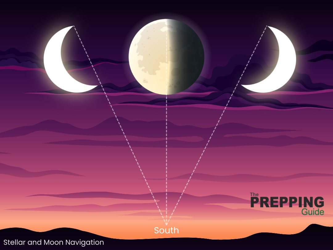
Navigating by the stars and moon requires practice and knowledge of specific constellations. However, some key celestial bodies offer valuable guidance:
- Polaris (North Star): In the Northern Hemisphere, Polaris remains nearly fixed in the night sky, always pointing north. Locate the Big Dipper constellation and draw an imaginary line through the two stars at the “tip” of the cup. This line points towards Polaris, your celestial guidepost.
- Southern Cross: In the Southern Hemisphere, the Southern Cross constellation provides a rough indication of the south. The longer arm of the cross points roughly towards the South Pole.
- First and last quarters (moon): During these phases, the moon rises in the east and sets in the west, roughly following the same path as the sun.
- Full and new moons: At full and new moons, the moon rises and sets closer to sunrise and sunset, respectively.
Remember, mastering these traditional techniques requires practice and patience. Start by experimenting in familiar environments before relying solely on them in unfamiliar territory. As you develop your skills, you’ll gain confidence and a deeper appreciation for the ingenuity and resourcefulness of traditional navigation methods.
Modern Navigation Tools and Techniques
While traditional methods offer valuable skills, modern navigation tools can significantly enhance your ability to find your way in the wild. Here’s an overview of two key tools:
Maps and Compasses
This classic combination provides a reliable and versatile navigation system, even when electronic devices fail.
Topographic maps, specifically designed for outdoor use, are essential tools. These maps depict not only roads and landmarks but also terrain features like elevation, rivers, and vegetation. Understanding map symbols and scales is crucial for interpreting the information they offer.
Here’s a quick guide on how to read a topographic map:
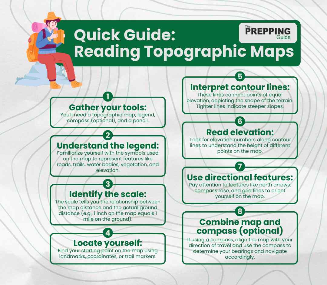
On the other hand, a compass utilizes Earth’s magnetic field to indicate north. Knowing how to use a compass in conjunction with a map allows you to determine your position, set bearings (directional lines), and navigate effectively. Mastering the concepts of magnetic declination, the difference between true north (geographic north) and magnetic north, is essential for accurate navigation.
GPS Technology
The Global Positioning System (GPS) utilizes a network of satellites to pinpoint your location on Earth with remarkable accuracy. GPS devices come in various forms, from handheld units to smartphone apps.
GPS devices are often user-friendly and provide real-time location information. Many GPS devices offer preloaded maps with various features, including terrain information, points of interest, and even turn-by-turn navigation on established trails. Some GPS devices offer emergency features, allowing you to send distress signals if needed.
However, GPS devices rely on batteries, and running out of power in the wilderness can be a significant setback. That is why carrying spare batteries is crucial. Dense vegetation, canyons, and other geographical features can obstruct GPS signals, rendering them unreliable in certain situations. Overdependence on GPS can also hinder your ability to navigate using traditional methods, potentially putting you at risk if the device fails.
It’s important to remember that GPS technology should complement, not replace, your understanding of traditional navigation techniques. By combining the strengths of both, you can navigate confidently and ensure a safe and enjoyable outdoor experience.
Navigation Planning and Strategy
Before venturing into the wilderness, proper planning and strategizing are critical for a safe and successful journey. Here, we’ll delve into route planning, wayfinding, and avoiding common navigation errors.
Route Planning and Wayfinding
Planning your route involves creating a roadmap for your journey, considering both maps and natural features:
Consult topographic maps: Carefully examine the map, identifying your starting and ending points, potential obstacles, and alternative routes.
Mark your path: Clearly mark your intended route on the map using a pencil or pen. Highlight landmarks, water sources, and any potential hazards.
Identify natural waypoints: Look for prominent landmarks like mountains, rivers, or distinctive rock formations that can serve as reference points while navigating.
Develop a wayfinding strategy: Determine how you’ll confirm your location on the map throughout your journey. This could involve taking compass bearings at regular intervals, using GPS waypoints, or cross-referencing your position with readily identifiable landmarks.
A 2022 study involving 25 university students investigated how people navigate in complex outdoor environments using virtual wayfinding. The study found that participants navigated more efficiently when shown reference images of their destination, taken from their perspective, compared to simply seeing the building’s facade. This suggests that matching the perspective of the information to the user’s point of view can be more effective for wayfinding.
Interestingly, the study also revealed that participants effectively combined the information provided on their phones (mobile wayfinding information) with the actual features of the environment (like road intersections and shapes) to determine their location and direction. This highlights the importance of combining different wayfinding resources for efficient navigation in complex settings.
In this video, Locus map walks you through the fundamentals of controlling the route planner straight from the map.
Avoiding Common Navigation Errors
Even experienced individuals can make mistakes in the wilderness. Here are some common navigation errors to be aware of:
Overconfidence: Assuming you know your way without proper preparation or underestimating the challenges of the terrain can lead to dangerous situations.
Failing to plan: Not having a predefined route, forgetting essential tools and supplies, and neglecting to inform someone of your trip itinerary are all recipes for trouble.
Ignoring environmental changes: Weather conditions, visibility, and even seasonal changes can significantly impact your navigation. Always be adaptable and adjust your plans accordingly.
Losing track of time: Time management is crucial in the wilderness. Ensure you have enough daylight to complete your journey and avoid getting caught in the dark.
Panicking when lost: If you find yourself lost, stay calm and prioritize safety. Conserve energy, seek shelter if necessary, and use your available resources (map, compass, GPS) to try and relocate yourself.
By investing time in thorough planning, utilizing a combination of traditional and modern tools, and staying mindful of potential pitfalls, you can significantly reduce your risk of getting lost and navigate your way through the wilderness with confidence and competence.
Challenges and Solutions
Even the most meticulous plans can encounter unforeseen circumstances. When visibility is limited, prioritize safety over progress. Stay put and wait for the fog to clear before attempting navigation. If necessary to move, proceed slowly and carefully, staying close to easily identifiable landmarks.

For heavy rains, it can impact visibility and make trails slippery. Reduce your pace, be extra cautious on uneven terrain, and pay close attention to potential hazards like flash floods or landslides. Utilizing a waterproof map and compass is crucial in such conditions.
Navigating at night requires additional preparation and resources. Headlamps are essential, and familiarizing yourself with celestial navigation using stars and constellations can be invaluable. Avoid traveling alone at night, and consider using reflective gear to increase your visibility if necessary.
Finding your way without a compass or map in an emergency situation requires a calm and resourceful approach. Here are some tips:
- Stay calm and prioritize safety: Panicking will only cloud your judgment. Focus on finding shelter, conserving energy, and signaling for help if possible.
- Follow natural features: Look for familiar landmarks like rivers, streams, or mountain ridges and follow their flow to reach civilization or find water sources potentially.
- Conserve battery life: If you have a GPS device, use it judiciously to conserve battery life for potential emergencies.
- Seek high ground: Climbing to higher ground can offer a broader view of the surrounding landscape, potentially revealing landmarks or helping you spot potential rescuers.
Remember: While these tips may offer guidance, emergency situations require careful evaluation and adaptation based on the specific circumstances. Developing a strong foundation in traditional navigation skills and practicing them regularly will enhance your ability to navigate the unexpected and make informed decisions in challenging situations.
Navigate with Confidence and Embrace the Adventure
Mastering the art of navigation, both traditional and modern, empowers you to explore the wilderness with confidence and a sense of self-reliance. Whether you’re an experienced outdoorsman or venturing into new territory, understanding these diverse techniques equips you to handle unexpected situations and navigate your way back to safety.
Remember, the key to effective navigation lies in preparation, practice, and continuous learning. Invest time in planning your route, studying maps, familiarizing yourself with various navigation tools, and honing your skills in controlled environments before relying on them in the wild. Don’t be afraid to experiment and learn from your experiences.
The Prepping Guide is dedicated to empowering individuals with the knowledge and resources necessary to navigate life’s uncertainties, both big and small. We believe that preparedness fosters confidence and resilience, allowing you to embrace any adventure life throws your way.
So, the next time you step out into the wild, remember the valuable lessons learned here. Embrace the challenge, hone your navigation skills, and, most importantly, enjoy the adventure!
FAQs
1. How do I choose the right compass for wilderness navigation?
A: Selecting the right compass is crucial for effective navigation. Opt for a reliable baseplate compass with clear markings, adjustable declination, and a durable build. Consider additional features such as a magnifying lens for map reading and a sighting mirror for accurate bearings.
2. Can I use natural navigation methods in conjunction with GPS technology?
A: Absolutely. Combining natural navigation cues with GPS technology enhances your overall navigational prowess. While traditional techniques offer timeless wisdom, GPS provides real-time accuracy. Embrace a balanced approach, harmonizing the efficiency of technology with the profound insights derived from celestial, land, and natural navigation methods.
3. What are the most common mistakes to avoid when navigating in the wilderness?
A: One common mistake is solely relying on technology without backup plans. Always carry a map and compass as a fail-safe. Misinterpreting topographic maps, neglecting to check equipment regularly, and not adjusting for declination are other pitfalls. Regularly honing your skills through practice ensures you’re well-prepared for any navigational challenges in the wild.
